Well I finally got around to compiling the obligatory statistics.
| Total Days | 17 |
| Days on the Road | 17 |
| Total Miles | 5,166 |
| Miles/Day | 304 |
| Low Mileage Day | 169 |
| High Mileage Day | 428 |
| Total Gas Stops | 35 |
| Total Gallons | 125.426 |
| Total Gas Cost | $373.95 |
| Average Miles/Gallon | 41.2 |
| Average Cost/Gallon | $2.986 |
| Low Cost/Gallon | $2.619 - Everett, WA |
| High Cost/Gallon | $3.449 - Ketchum, ID |
| Total States Visited | 9 |
| Total Provinces Visited | 0 |
| Total National Parks Visited | 7 |
| Total National Monuments Visited | 2 |
| Total National Rec. Areas Visited | 1 |
| Lowest Temperature | 40° |
| Highest Temperature | 94° |
| Lowest Elevation | 38' |
| Highest Elevation | 9910' |
| Days With Some Rain | 4 |
| Baseball Bats Under the Bed | 0 |
| Mornings Without Hot Water | 0 |
| Nights in Motels | 16 |
| Average Cost per Night | $74.01 |
| Wireless Connections | 14 |
| Wired Connections | 1 |
| Telephone Connections | 1 |
Web statistics can be really tricky. Most people talk about 'hits'. The problem with hits is that if you open a site like our main 3 Flags Page, all 3 flag images are loaded as well as the image of the background texture - so you get 5 hits for the one page. If you want to know more than you care to about this subject, see this link for info on web site statistics. For our purposes we will look at visits even though we acknowledge that it may not be perfect.
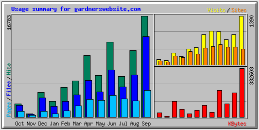
This chart shows the year to date stats for our site:
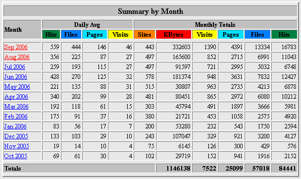
As you can see, we had 2242 visits during the August/September time frame. This compares to 741 last year during the same time frame. Not sure if that's good or bad - it just is. Here are the statistics by day for those two months.
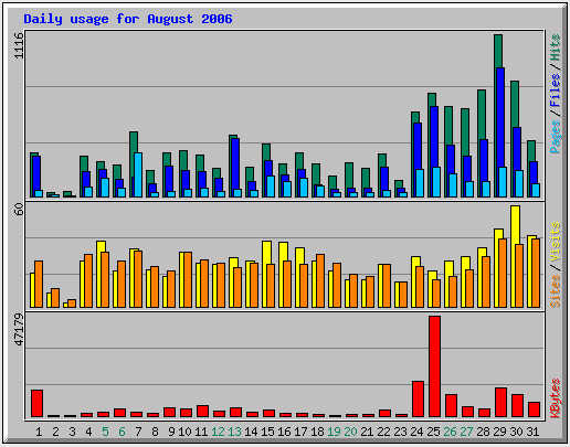
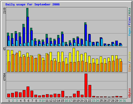
It looks like the biggest days were August 30th with 72 visits and September 18th with 78 visits.
Overall it was a great trip. We set out to stop a little more often this year since we have a tendency to get on the road and just keep going. We did a pretty good job of meeting that objective based on our average daily mileage of 304 miles per day versus last year when we did 368 miles per day. There was also very little rain. We actually put our rain gear on more often because of the cold than because of rain. In fact the only times we really needed to put on rain gear for rain were leaving Everett and then returning back over Snoqualmie Pass. Based on how often we needed rain gear for the cold, we may seriously look into heated vests for next year. They are light, don't take up much space, and apparently work very well.
Again this year our motorcycle worked great with absolutely no problems. Despite that, we are talking about a custom seat for next year. The stock seat is not bad but the custom ones tend to be much more comfortable. We are currently looking at the Russell Day Long Seat. The Garmin Forerunner again worked like a champ for plotting our route each day. The new Canon A620 camera was also a winner. In the past we got a lot of blurred pictures with the old camera from taking pictures while moving, but this year we got very few with the new camera. It also starts up and is ready to take a picture much faster than the previous camera and, although it didn't affect us on this trip, the flash recycles much faster than our previous camera. Finally the RoboGeo software was flawless. It let us create Google maps and Geotag our pictures each day. The process was fun but it takes quite a bit of time. We probably spent 1-1/2 to 2 hours each night reviewing and selecting pictures, renaming and resizing the pictures we wanted to use, combining track log files from the Forerunner, creating the Google maps, doing the write-up to go along with the map, and finally uploading all of the files and making sure everything worked correctly. Then, on nights when we had a lot of pictures to upload, like from the National Parks, we had to create the photo album and get all those pictures uploaded as well. Next year we definitely plan to streamline the process somehow.
Speaking of uploading files to the site, we were amazed at the number of motels with wireless Internet access. Last year maybe half of the places we stayed had wireless and some of them charged for the access. At that time we thought that at some point it would become like color television or cable -- all motels would have it. Well that time is here. The only motel that didn't have Internet access was on the Blackfoot Nation Indian Reservation and they didn't have access anywhere in town -- it was a pretty small town. Some of the motels had better access than others with multiple routers placed strategically around the site but they all seem to get it. They need to have wireless access just to keep up.
So I guess it's time to think about next years trip. We only have two thoughts at the current time. One is to try to get pictures of a welcome sign from all 48 states. I think we could probably do that in 4 to 5 weeks and 12,000 to 13,000 miles. The other thought is the Gaspe Peninsula in Quebec, Canada. We thought about it on last year's trip since we were almost there anyway, but in the end we just didn't have the time to do it justice. We could do the sections along the St. Lawrence that we missed last year, travel around the Gaspe Peninsula, and then drop down into New Brunswick to tour that area. The only issue is that it would take 8 - 10 days each way on roads that we have done numerous times just to get there and back. That being the case, we may look into trailering the bike back to Cleveland, leave the car and the trailer at my mom's house, and then start and end the trip from there. We'll have to think about that.
I forgot to mention, Fred emailed us this picture while we were on the road. Apparently someone sent it to him claiming that it was a picture of Linda and me. Fred decided that it was probably not us since he couldn't spot my beard. I think he was right.
Until next year then, thanks for joining us.