![]()
2008 Trip - Day 1
![]()
|
|
2008 Trip - Day 1 |
|
Start Location: Everett, WA
Ending Location: Pendleton, OR
Miles Today: 363
Trip Miles: 363
States Visited: 2
Provinces Visited: 0
Low Temp: 47.6° F
High Temp: 75.8° F
Min Elevation: 28'
Max Elevation: 3102'
Route Map:
For a change we left in bright, sunny weather this morning. It's frequently either overcast or raining when we leave on a trip. It was a little cool though so we donned our vests and headed out for Snoqualmie Pass. Since the temperature was in the 50's and the sun was out, we wore our vests under our leathers but didn't bother to plug them in. This was probably a mistake - it got down into the 40's over the pass and we were both wishing we had the extra heat. We did stop at a rest area on the other side of the pass and got plugged in and were more than comfortable the rest of the day.
We stayed on Route 90 and then 82 until Yakima and then got off the highway and followed 97 down through Goldendale and on to the Columbia River. Here we turned left and traveled 14 along the river. We have traveled this route numerous times over the years and always enjoy it. The road is very nice and there is very little traffic. The river and terrain change numerous times along the route and it's always an interesting ride. Linda tried a little experimenting with the pictures and we didn't get quite as many as we planned. We'll work on that tomorrow.
Finally we hooked up with Route 82 again and crossed the river into Oregon where we picked up Route 84 and headed to Pendleton where we stopped for the night. Tomorrow we plan to begin following 395 south through Oregon and into California. Although that's the plan, it's subject to change depending on the weather in the morning.
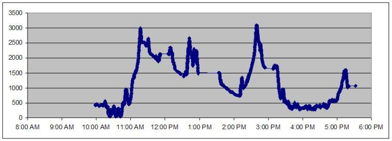
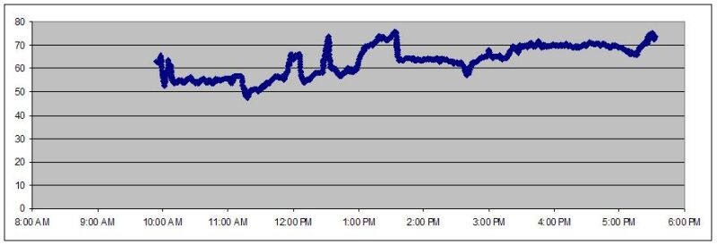
I guess I wasn't quite as prepared as I thought I was tonight. Although the new data logger worked fine and saved the log correctly, it took a little more effort than I had planned to convert the raw data into a format to plot the temperature and elevation profiles. I did finally get profiles but the effort is still a work in progress and may look different over the next couple of days. The map came out fine and that's the important part.
So here's the temperature profile:
and here's the elevation profile: