
National Parks - 2012 Trip - Day 3

|
|
National Parks - 2012 Trip - Day 3 |
|
Start Location: La Pine, OR
Ending Location: Carson City, NV
Miles Today: 398
Trip Miles: 919
States Visited: 4
National Parks: 0
National Monuments: 1
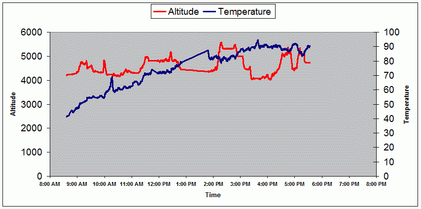
Low Temp: 41.3° F
High Temp: 94.6° F
Min Elevation: 4023'
Max Elevation: 5576'
Route Map:
Holy crap! It was 32 degrees outside when we got up this morning. Fortunately it warmed all the way up to 41 degrees by the time we were ready to leave. It sounds cold but it was sunny and not really too bad. We wore our vests but didn't bother to plug them in. By noon it was 70 and it got into the low 90s by the late afternoon.
We decided we needed to pick up the pace a little bit or we'd never get as far as we planned in a reasonable period of time. With that in mind, we kept moving most of the day and put in just short of 400 miles while still getting into the motel by 5:30.
After leaving La Pine, we picked up route 31 which headed southwest for about 120 miles through pine forests, prairie, and ranch land. There was almost no traffic and it was a pleasant ride.
We finally met up with 395, our original planned route, about 40 miles north of the Oregon/California border. From there we stayed on 395 the rest of the day. Although the ride was nice and the traffic light, the ride was somewhat unremarkable. The most interesting thing we saw were 3 or 4 lakes with no water. Apparently, although these were very big lakes, they are very shallow and dry up almost every summer. There are a few pictures but it's kind of hard to see from the pictures. We also had 2 more construction delays that contributed to almost an hour of lot time. Both of these delays were the type where they allow traffic in only one lane so you have to wait for a pilot car and then follow them in single file. At the first delay we must have waited 15 minutes just for the pilot car and then followed it at low speed for 4 or 5 miles and there was not a single sign of any construction - very strange.
Later on, coming out of Alturas, Ca, there was a sign telling us to tune to a certain station for a traffic advisory. The advisory warned us of roadside fires 70 miles to the south with the possibility of road closures. We decided to take our chances only to find out from a transportation worker at a rest stop that that warning was from last week and they hadn't removed it yet. We did see many signs of fire as the whole sides of some of the mountains were blackened. We have a few pictures but again, due to distance and haze, they aren't very good.
Tomorrow we should be on 395 all day and should end up outside Joshua Tree National Park.